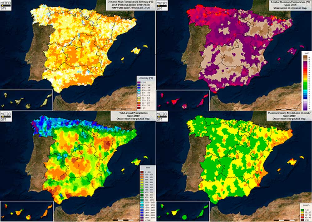
Data registered from a year marked by historical heat waves and by “DANA” affecting the east of the Iberian Peninsula. Let’s analyze with these 4 maps how this past year has been.

A year warmer than usual.
2019 has been a clearly warm year in most of the territory. There is no doubts according to the comparative between the mean temperature values recorded on 2019 and the ones of the historical period of the last 30 years (1988-2018): positive anomalies (yellow to red colors) spread across the Iberian Peninsula and both Balearic and Canary Islands. The year has been specially warmer than usual in much of the Central Plateau and southeast, as well as in the main mountain ranges, where the positive anomalies has even increased more than 1.5ºC.
A very hot summer, head by a record-breaking month of June.
Most of the annual maximum temperatures recorded in 2019 were registered during June, unlike what was expected from a climatological point of view (July and August). The reason: a significant heat wave that affected a large part of the territory during the last days of this month, especially in the east of the peninsula, which led to new records of maximum monthly and annual temperatures. The Ebro Valley was the zero-zone of the heat, as another heat wave recorded during the month of July was also particularly strong in this area.
In fact, the warm air masses hit most of mainland Europe, establishing new maximum registrations in countries such as France, the United Kingdom, Belgium or Germany, and leaving unusual values, such as the more than 42ºC registered in Paris.
Uneven precipitation: drought on the inlands.
Rainfall distribution during 2019 has been very irregular. As usual, the highest values are found in Galician and Cantabrian regions, with accumulated rainfall above 1000 mm. However, the year has been dry or very dry in most of the centeral and southern peninsula. In particular, many areas of the Central Plateau, Ebro Valley and southwestern part of the Iberian Peninsula have not reached even half of the expected climatological values.
Torrential rainfall in the Mediterranean: “DANA” is trending topic.
On most of the Mediterranean coast, rainfall has been higher than usual, largely due to several torrential rains during the year. Up to 3 isolated depressions in high levels (“DANA” in Spanish) have affected various areas of the Mediterranean communities during the months of April, September and December, leaving records of historical flooding in areas such as the Mar Menor (Murcia) or the Vega Baja (Alicante).
In summary, it is easy to see that 2019 has been a very active year, meteorologically speaking, where extreme events have been felt in large areas of the national territory.. At Meteosim, we keep on working to achieve the best forecasts which allow us to diagnose this kind of severe weather events and to remain alert to its consequences.


